Which Route is Best?
This is not an official study, it is entirely independent.
The industrial park (known as Vaughan Business Park) north and east of Vaughan Metropolitan Centre station is (from what I have seen) a strong generator of bus ridership in the area. As part of their 2026 Annual Transit Plan, York Region Transit (YRT) is proposing a routing change in the area. As part of the change, a new weekday daytime service will be introduced between Vaughan Mills Mall and Vaughan Metropolitan Centre Station via Creditstone Road, supplementing the existing peak-only Edgeley and full-service Jane routes. Is this the best plan for the area?
Probably not.
If you would like to see the direct comparisons that led to the recommended solution, see the test cases documents with and without the Jane BRT.
Draft Recommended Solution
Within the study area (south of Vaughan Mills Terminal and east of Highway 400), the only needed routing change is for Route 26 - Maple to continue running on Edgeley in addition to Route 29 - Edgeley. In addition, Route 29 should be renamed to avoid confusion and both routes should run on a blended schedule to allow for 20- to 21-minute service during rush hours. Routings north of Vaughan Mills are out of this study's scope.
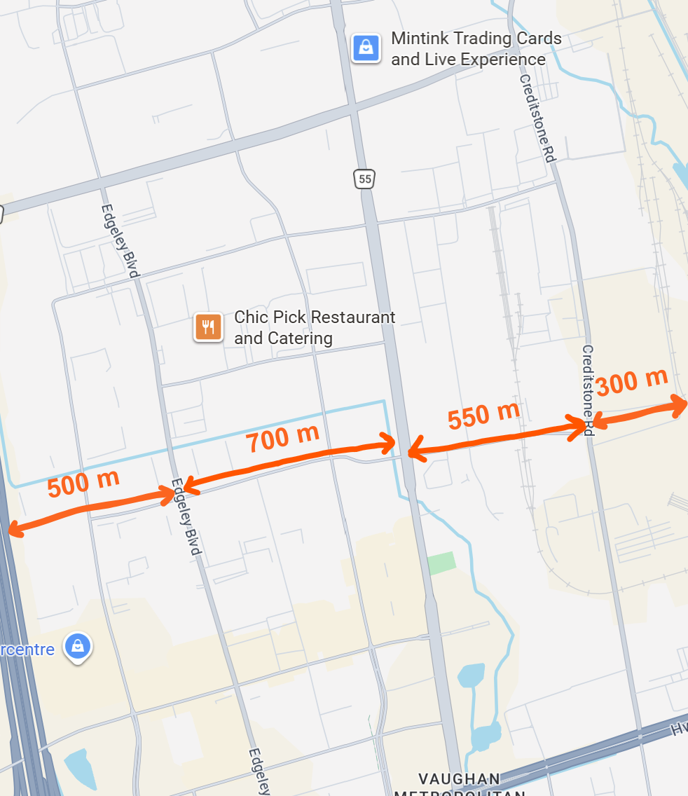
This recommendation was decided based on the lack of ridership potential along Creditstone Road, primarily due to it being 500 metres from Jane Street and being the last road before CN's MacMillan Rail yard, preventing any employment buildings from being built any more than 200 to 300 metres east of Creditstone and not on any road east of there. The frontage of these buildings is only around 600 metres east of Jane Street at most.
Edgeley, by contrast, is around 700 metres west of Jane and usually has 500 metres and a road further west before Highway 400, increasing the walkshed in both directions. This gives Edgeley a notably bigger cross-section along which it can attract riders. Additionally, the Creditstone route does not reach Creditstone Road until 750 metres north of Vaughan Metropolitan Centre, further reducing the area from which ridership on the route can be drawn. Creditstone has fewer intersections resulting in fewer stops as York Region Transit (YRT) does not like using mid-block stops (jaywalking), but this is likely less of a factor as this simulation included a midblock stop and multiple at one-way stop-controlled intersections.
Simulations both at the macroscopic level and those simulating individual riders found ridership was universally higher and travel times lower when Route 26 - Maple was routed on Edgeley (whether or not schedules were blended), with blended schedules improving conditions even further. Additionally, the higher ridership potential gives midday service on Edgeley Boulevard much more potential than on Creditstone Road.
Since Edgeley Boulevard is west of Jane Street and Route 26 - Maple will continue to use Vaughan Mills Terminal when it runs on Creditstone (unlike in the original proposal), Edgeley will be no slower for riders north of Rutherford than Creditstone, so there should be no negative impacts on ridership north of Vaughan Mills (except for the potential 1 or 2 minutes' additional headway resulting from a blended schedule). 26 - Maple additionally appeared to be a great route for midday service due to its connection to Maple GO Station, which the other rush-hour routes in the study area do not have.
More details on the macroscopic model can be found below. More details on the individual simulation model, the main one used for this study, can be found below as well. For more information on how the finer model was used to come to this conclusion, see the test cases document.
Jane BRT
The Jane BRT, a project to replace Route 320 - Jane Express with a Bus Rapid Transit line running through the study area along Jane Street, was undergoing public consultations while much of the scenarios were being run on the finer model. A project team member somewhat familiar with my work requested I include the Jane BRT in this project, but I maintain complete editorial control over this project and the team member in question has not seen the results prior to their publication.
To avoid assuming speeds (the project team assumes 30 km/h, compared to the 24-29 km/h of 320 - Jane Express) and frequencies, I included cases with a wide range of headways (6-15 min. during peak hours, 8-20 min. during miday hours) and speeds (15-35 km/h) which I felt were realistic. The study area has much faster speeds for Routes 20 and 320 compared to outside it, so the benefits of the BRT will likely be larger for those immediately north of the study area.
Additionally, I am assuming Route 20 - Jane will have its frequency reduced to 20 or 30 minutes when the BRT is implemented. I do not believe it will be less frequent due to the employment areas it goes through having a large amount of local demand.
Since the walk from the Jane BRT's Highway 7 station is expected to be outside (rather than in a tunnel like at SmartVMC Terminal), I applied the bus travel time to the nearest subway station entrance as a penalty.
Based on the results of the Jane BRT scenarios, the Jane BRT will need to be both fast (not Finch LRT speed) and very frequent (at least 10 or 12 minute depending on the hour) to succeed, with frequency being most important factor. Due to current bus allocations on Jane Street (two routes running at least every 17 minutes until past 10pm), it should be very easy to get a highly frequent BRT on Jane without adding additional resources to the corridor.
With the Jane BRT included, the positive impact of running more service on Edgeley becomes even more clear, along with the necessity of fast, frequent service on the Jane BRT. The Jane BRT will most likely improve outcomes within the study area, and due to the slower nature of Route 20 north of there it will be even more beneficial further north. Whether a branch should run to Teston Road (a likely suggestion to avoid a transfer) is out of this study's scope, but it should be studied.
More General Information on the Study
Area and Scope
The study area is shown below, comprising the areas of the Vaughan Business Park south of Vaughan Mills Mall. The macroscopic model used assumes all employees closest to the existing frequent route on Jane Street will use it, while every other potential rider will use it if the perceived time to Vaughan Metropolitan Centre is shortest, as based on the TTC's service standard . The microscopic model attempted to model individual behaviour. Both models were written in C++.
Macroscopic Model
Further description of the model can be found here.
This model was built with a number of assumptions to simplify the situation, allowing it to be run on the fly and test many different cases. I treated this code like the solution to a programming problem, the type often seen in programming competitions (unrelated example problem).
The model assumes three possible routes. The 2nd (middle) route already exists (meant to model route 20 - Jane) and will be kept. The routes to the left and right may not exist and the model may decide those routes should not exist (meant to model the proposed routes of 29 - Edgeley and 26 - Maple through the study area).
In a theoretical case, with routes spaced 1000 metres from each other and no extra distance walking to bus stops is needed (apart from horizontal distance), the parallel route 1000 metres away becomes necessary around when there are enough buses to run it around every 11 minutes, at which point the most efficient bus allocation is running both routes every 20 to 21 minutes. At the point when having only one route is no longer the most efficient option, having a less frequent secondary route is always better as long as it runs at least around every half hour.
With a shorter distance, the headway would need to be shorter to justify this. With a longer distance, the headway can be longer. The distance and number of buses required appear to be roughly but probably not exactly proportional to each other. However, at longer distances (e.g. 2000 metres) people may not choose transit. I am unsure of how to work such a situation into my model and would advise avoiding looking at distances longer than around 1,500 metres.
The Edgeley route is around 700 metres away from Jane, while Creditstone is around 550 metres away. However, Edgeley has a larger catchment area due to the railway terminal east of Creditstone Road. Both the routes on Creditstone and Edgeley are too infrequent to be the most efficient option, though there is likely an additional 200-400 metre walk to any bus stop. The two less-frequent routes certainly come less frequently than they would under an "efficient" option. However, route 20 - Jane is already well above the 20-minute service level so the total number of buses would likely merit the more minor routes.
A finer model
Further description of the model can be found here.
This model simulates individual decisions on which route to take (bus routes and walking) for a random sample of passengers and outputs the ridership for bus routes going through the area. This model relies on an assumption that with similar land use throughout the study area, the area of each building is relative to employee density. Buildings with 3 more more storeys get a multiplier smaller than their number of floors (as these tend to be office buildings where people are probably more likely to drive). If you would like to see the areas and distances used for this, see this map . Additionally, it assumed the same percieved walking and waiting times assumed by the TTC and in my earlier macroscopic model.
You can find the code I have used to run the model here. Expect further information about the model in mid-June. The model is based on areas and distances determined by the map, existing schedules on the YRT routes in the area, and various speed assumptions for the new route on Creditstone ranging from 17 to 30 km/h (and one 50 km/h case made mostly as a joke). All cases tested used a sample size of 20,000 to ensure the margin of error would be very small.
The results indicate a route along Creditstone would get very little ridership. Even if the route ran at 50 km/h, ridership is expected (by my model) to be at most a third of the ridership on Edgeley. During midday hours, running a route on Creditstone instead of Edgeley would (according to my model) decrease ridership in the area by around 5% and increase ridership on the busy 20 - Jane bus by over 10%. Interestingly, improving the 20 - Jane would be more effective at saving area commuters' time than a new Creditstone midday service, but not as effective as a new Edgeley service.
Could these models be used elsewhere?
These models are suitable for areas with very similar land use where the vast majority of travellers are going to one point (Point 0, typically a subway station). This model could be modified to specify more zero-distance points, which may be useful in other areas (e.g. evaluating whether an extension of the Pharmacy North bus would effectively serve commuters to the industrial park north of Steeles).
The business park north of Vaughan Metropolitan Centre is a great area for such a model due to the aforementioned subway station as well as being disconnected in the east-west direction due to Highway 400 to the west and the CN Rail yard to the east. The aforementioned area near Pharmacy Avenue has a railroad in the east, though it is a much lesser wall than the CN yard is.
Last updated: 06/21/2026